

questa mappa è proprio sbagliata. qui non c'è nemmeno il problema della risoluzione, questa mappa è sbagliata totalmente per il NI.Originariamente Scritto da zione

Si vis pacem, para bellum.

Comunque, basta vedere che hanno ricostruito l Inverno 1829-30 a -5.3 dalla media in Italia (siii lo sappiamo Inverno gelido nevosissimo il più freddo sulle Alpi etc etc) per capire l affidabilità delle ricostruzioni ... neanche il Wurm
NAPOLI, Febbraio 2018: IO C'ERO !!!
Inizio rilevazioni Gennaio 2002, estremi: -3.6 (2014) +38.3 (2007)
Per carita', hai anche ragione: pero' credo che il problema principale di quelle mappe sia appunto il numero esiguo di stazioni usate (correggimi se sbaglio, eh !), ergo il risultato e' una "spalmata"
grafica delle anomalie assolutamente non significativa (se non addirittura errata !).
Si usassero maggiori stazioni, pur con qualche eventuale differenza anche clamorosa come quella da te evidenziata, pero' il risultato sarebbe ben diverso e piu'....coerente, ovviamente !
Ripeto, se il problema sta principalmente a monte (poche stazioni) tali elaborazioni diventano a mio modesto parere quasi inutili, se non forvianti: meglio non farle, come dicevo prima, a questo punto !
P.S.: si riesce ad avere con le ns. stazioni in rete (MNW) delle mappe, se non per regione ma almeno per macro aree (Nord-Centro-Sud), non ovviamente con le anomalie ma con i dati (chesso', Tmedia e prp cumulata), suddivise per mesi e/o stagioni (ad es. estate, tanto per rimanere in tema) ? Non ricordo piu' se si puo' fare (e dove, eventualmente) !

Sulle anomalie termiche non entro nel merito, ma su quelle precipitative dire che quella mappa è sbagliata è farle un complimento...e non mi par di esagerare nel dirlo
Ad agosto vedono nella mia zona un'anomalia del 50% rispetto alla media...tutti in l'hanno raddoppiata se non oltre e non c'è UNA (una eh) stazione in tutto il nord-ovest che abbia chiuso al 50% della media...ma forse non ci sono neanche stazioni che han chiuso in media. Bene o male sono tutte sopra, chi più chi meno
Quindi come si siano "inventati" quella mappa tutta rossa per me resta un mistero
Anche il discorso "eh ma sono temporali" quest'anno vale poco, perchè le realta che hanno chiuso sopramedia pluvio sono enormemente più numerose di quelle che han chiuso sottomedia
Senza contare che ci sono molte zone che questa media l'hanno triplicata e anche più, vedi per esempio l'alta Lombardia, che nella mappa risulta tutta sottomedia
Cioè, va bene che le precipitazioni estive variano spaventosamente in pochi km, ma cavoli...a vedere quella mappa sembra che l'Italia sia uscita dall'estate 2003
Mah...consentitemelo
Ultima modifica di Nix novariensis; 03/09/2014 alle 09:42
Altra assurdità
Pluviometricamente quest'estate risulta quasi identica alla 2006
Peccato che nel 2006 razionassero l'acqua dalla siccità che c'era e quest'anno tra un po' finivamo alluvionati
\fp\
mean_su_ita_PCP.jpg
assurdo davvero, non ha senso per niente. ci sarebbe da scrivere una mail. Sicuramente con le stazioni di MNW verrebbe fuori un lavoro 10mila volte migliore.
Si vis pacem, para bellum.
l'Estate 2006 al Centro-Sud fu abbastanza piovosa, a tratti più di questa però questo non giustifica il dato
mi sembra assurdo anche il dato dell'Estate 2002, non il dato in se ma confrontato a quello di quest'anno, cioè l'Estate di 12 anni fa chiuse abnormemente sopramedia pluvio e questa qui in media ?
NAPOLI, Febbraio 2018: IO C'ERO !!!
Inizio rilevazioni Gennaio 2002, estremi: -3.6 (2014) +38.3 (2007)
un altra cosa che non mi torna minimamente è questa distruzione delle stazioni: vengono usate anche quelle del NOAA BEN OLTRALPE e sul Nord Africa per generare la media ? Va bene l'idea della griglia, vista la disomogeneità delle stazioni fra N e S, ma sul serio vengono usate anche quelle stazioni al di fuori ?
grid_TMM.jpg
NAPOLI, Febbraio 2018: IO C'ERO !!!
Inizio rilevazioni Gennaio 2002, estremi: -3.6 (2014) +38.3 (2007)
aggiungo che quelle poche abbiamo visto benissimo che a volte termicamente siano inaffidabili
e gli addetti ai lavori curano altri aspetti primariamente:
dati termici e pluvio sono un aspetto secondario del loro dovere di lavoratori.
Questa è la rete di stazioni pluvio per rinfrescarci la memoria:
grid_PCP.jpg
il fatto di avere una fitta rete di stazioni non è anche indice di buona qualità dei dati,
basta lasciarla al suo destino senza manutenzione, come succede da anni su alcune con i dati termici.
sì certo, per verificare l'omogeneità dei dati,per la correzione eventuale da fare,
fu ben spiegato il metodo gridding da elz in altro thread:
[SIZE=h2] GRIDDING METHOD [/SIZE] [SIZE=h1] The grid has one degree resolution, both in latitude and in longitude, and was realised with an interpolation technique based on a radial weight and an angular term.
The radial term was realised with a gaussian weighting function with the following form:
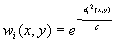
with

where i runs along the stations andis the distance between the station i and the grid point (x,y). With this choice of the c parameter, we have weights of 0.5 for station distances equal to
from the grid point we want to calculate.
is defined as the mean distance of one grid point from its next one obtained by increasing both longitude and latitude by one grid step (it is a sort of mean length of the grid mesh diagonal).
For a grid resolution of 1 deg (as in this case) the
The angular term accounts for the geographical separation among the sites with available time series. It has the following form:

whereis the angular separation of stations i and l with the vertex of the angle defined at grid point (x,y).
The final weight is the product of the radial and the angular terms.
Each grid point was calculated under one of the following conditions: i) a minimum of two stations at a distance lower than
In order to avoid biases due to the different lengths of the station records, for temperature we calculated the grid values starting from the anomalies, whereas for precipitation we started from the relative deviations from the means. The conversion of these anomalies (relative deviations) into absolute values requires the knowledge of the monthly normals at the grid point.
Available grid boxes are indicated in the two figures, both for temperature and precipitation, together with the stations involved in the grid computation.
The national mean seires were obtained by averaging all grid boxes over the italian territory and not the station anomalies.
The reason is as follows:
The availability of station data is typically not sufficient to ensure an even distribution of stations throughout a network. But by averaging station anomalies within regions of similar size (grid boxes) and then calculating the average of all the grid box averages, a more representative region-wide anomaly can be calculated.
This makes grid box averaging superior to simply taking the average of all stations in the domain. A network of 1000 stations could theoretically have 700 stations in the northern half of the domain and 300 stations in the southern half. A simple average of the stations could easily create a bias in the domain-wide average to those stations in the north. [/SIZE]
Ultima modifica di Alessandro(Foiano); 03/09/2014 alle 10:49
CNR? quelli che a febbraio se ne sono usciti con una previsione per un'estate 2014 torrida, temperature elevate e clima secco.
Cnr, verso Estate 2014 torrida, temperature elevate e clima secco - C.M.I.
\fp\
 Permessi di Scrittura


 Rispondi Citando


Segnalibri