

beh in effetti è possibile che l'estate sia più simile alla 2014 che alla 2007Originariamente Scritto da snowaholic

magari sarà una via di mezzo
Le carte attuali secondo me qualche lieve indizio già lo stanno dando
Ho pensato un attimo fossero le previsioni per metà Giugno.
Poi ho visto il viola, e letto 2021.
Dai, su, prepariamo le live?
Mancano solo 6432 h
No!
Prima ci vuole il permesso del Vate...
Da quando è scomparso non ne va bene una
Modelli nettamente peggiorati stamane mi pare
Reading è stupendo. Fresco (che poi, fresco...erano le medie 51/00...quelle di una volta) e a tratti piogge e temporali.

Per domani (ovvero oggi)
... cold front of the second frontal system: from N Poland to S Italy ...
Rather moist air under modest lapse rates contributes to CAPE on the order of 500 J/kg ahead of the slowly advancing cold front. An overlap with a pronounced southerly low-level jet creates quite remarkable 0-1 km shear, reaching around 10 m/s across wide areas and even up to 15 m/s across the Pannonian Plain in Hungary and around. Vertical wind shear does not increase much across deeper layers anymore, but appears nonetheless sufficient for storm organization.
The main trough axis lags several hundred kilometers behind the cold front, hence little synoptic-scale lift support exists. However, the cold front itself, various outflow boundaries surging ahead, smaller-scale vorticity maxima and orography provide plenty of mesoscale sources of lift. Scattered thunderstorms are therefore expected mostly between noon and late evening.
Almost front-parallel storm motion will likely result in destructive interference and undercutting cold air, hence excessive rain seems to be the primary risk, especially in case of backbuilding or training activity. However, leading storms which manage to propagate towards the warmer air can organize well and pose an increasing risk of large hail, severe wind gusts and isolated tornadoes. While most areas are covered with a level 1, a belt across S and central Hungary and an area of S Italy are upgraded to a level 2, mostly due to steeper lapse rates and higher CAPE up to 1500 J/kg. It is difficult to give any details about the expected storm mode, but there are indications for a maximized wind risk in Hungary (possible bowing segments under strongest 0-1 km shear) and a maximized rain risk in S Italy (strong warm air advection ahead of a Saharan elevated mixed layer plus orographic lift of the southerly flow).
Towards the far south, i.e., Sicily, Malta and around, the capping will likely be too strong to be eroded by a combination of the mentioned sources of lift. The level 1 is therefore extended across Sicily, where the orography is still helpful, but not beyond it towards Malta and the open sea.
2020060606_202006042359_2_stormforecast.xml.png
Inverno 2011/2012: 6-7 Febbraio 2012 (3 cm a terra, 7-10 cm eolici)My sitometeo con dashboard di tutti i dati della mia stazione aggiornati ogni minuto --> http://marconiameteo.altervista.org/
Ultima immagine 4K (aggiornata ogni minuto) --> https://assets3.webcam.io/w/P1a2OP/latest_hd.jpg
My Webcam 4K in Marconia (MT) - direzione N (si vedono 2/3 della Puglia + Adriatico) --> https://webcam.io/webcams/P1a2OP (timelapse)
Inverno 2012/2013: 9-10 Febbraio 2013 (Neve farinosa)
Inverno 2013/2014: l'inverno del nulla cosmico.
Inverno 2014/2015: el buco metapontino
Inverno 2015/2016: nada de nada
Inverno 2016/2017: 6-7-8-9-10 Gennaio 2017 "The Story" (>20cm)
Inverno 2018/2019: 3-4 Gennaio 2019 "Goduria (>10cm)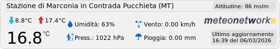
di luuuusso
è stato bello finché è durato
Dai Cri, nessun eccesso tutto sommato
Ma vediamo
 Permessi di Scrittura


 Rispondi Citando


Segnalibri