


Appena ho aperto il Sat m'è venuto un colpo poco fa
La propagazione a 360° non l'avevo MAI vista, anzi, pensavo fosse anche molto improbabile...invece con correnti deboli molto spesso si riescono ad osservare fenomeni davvero molto rari come questo
Francesco Dell'Orco
ottimo outflow boundary!Grazie Pier

Giaime Salustro
Always Looking at The Sky
W il Thunderstorm Team!
www.thunderstormsardiniateam.tk
"Esiste anche un F5 per caso?"
"............"
"E come sarebbe?"
"COME IL DITO DI DIO." (TWISTER)
NEVER STOP CHASING!
Ecco qua l'animazione Sat + Rad dell'accaduto.
Siamo stati anche fortunati che il radar Arpa ER ha letto anche il boundary layer!
Meteocattolica.eu / Meteogabiccemare.eu : Osservatorio Meteorologico di Cattolica e Gabicce Mare
Severe Weather Europe - Follow Severe Weather as it happens. Anywhere. Anytime.
always looking at the sky
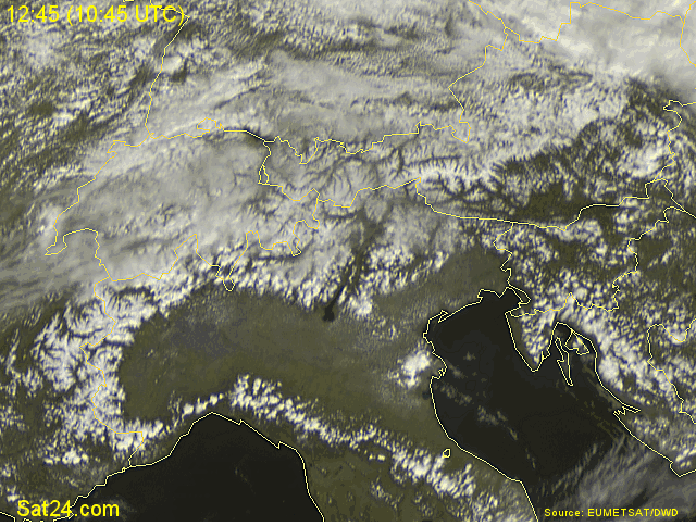
Notare come vada a creare convergenza con la massa dan ord rinvigorendo le celle in discesa dalle alpi
Originariamente Scritto da Ale92

[IMGS]http://meteosangiorgio.altervista.org/autoscaletemphum.gif[/IMGS]
Actually that is not a clear outflow boundary. At first it is an outflow boundary from those few storms in delta Po (few scans), but later its obvious the converging line of cumulus comes by the wind from the Adriatic sea (sea breeze) which is stronger in April than usually during summer due to big temprature difference between near surface layers over Adriatic and over Po valley. Thats why it gets deeper across the Po valley towards the NW, as seen on the satellite. You can notice it all along the Italian coast from south Friuli down to almost Rimini... and it often gives similar Temp/Rh graphs like the one posted above.
These two things can get mixed sometimes as its becomes tricky to determine both
Marko Korosec, Slovenia
Severe Weather Europe - http://www.severe-weather.EU
www.Weather-Photos.NET | http://www.facebook.com/WeatherPhotos.NET
I completely disagree with you...
The inland boundary of the sea breeze it's clearly visible during the whole satellite loop and it remains stationary at about 8-10 miles far from the coast. Why should sea breeze gain hundred of miles inland only (only!) near central "Pianura Padana" and not in Northern Veneto or in Romagna?
Even the speed of that "mesoscale front" is not compatible with sea breezes' one... Too fast!
Finally, it is true that sea breezes are relatively strong during this season, but not so much!
Ultima modifica di miki; 15/04/2010 alle 23:18
concordo.
Meteocattolica.eu / Meteogabiccemare.eu : Osservatorio Meteorologico di Cattolica e Gabicce Mare
Severe Weather Europe - Follow Severe Weather as it happens. Anywhere. Anytime.
always looking at the sky
I agree with you there, but as I already said above, I was reffering to a later evolution. See this animation later in the afternoon:
And said once again; at first stages its exactly what you said... so a clearly visible sea breeze "front" staying close to the coast line. There, storms initiation occured along that sea breeze frontal convergence and produced an outflow boundary which was shifting westwards into central Po valley. But later on, the sea breeze "front" gets pushed inland more... all the way from the coast... see the above animation . I would agree its "only" an outflow boundary if only the delta Po would be affected later, but notice the boundary moving SE->NW over Venezia all the way to the mountains and E->W near Rimini as well. If the outflow boundary came from Rovigo area, then it was going NE towards Venezia, not from SE-NW.
Anyway, this was indeed a nice textook ouflow boundary at first stages
Marko Korosec, Slovenia
Severe Weather Europe - http://www.severe-weather.EU
www.Weather-Photos.NET | http://www.facebook.com/WeatherPhotos.NET
Giusta analisi!
ITA.TOR - ITAlian TORnado Research Project
CENTRO STUDI TORNADO, TLE e FENOMENI VORTICOSI IN ITALIA (in collaborazione con l'Ass. MN e il TT).
All rights reserved
 Permessi di Scrittura


 Rispondi Citando


Segnalibri