
Originariamente Scritto da
boyroma18

Ottima analisi Fra..
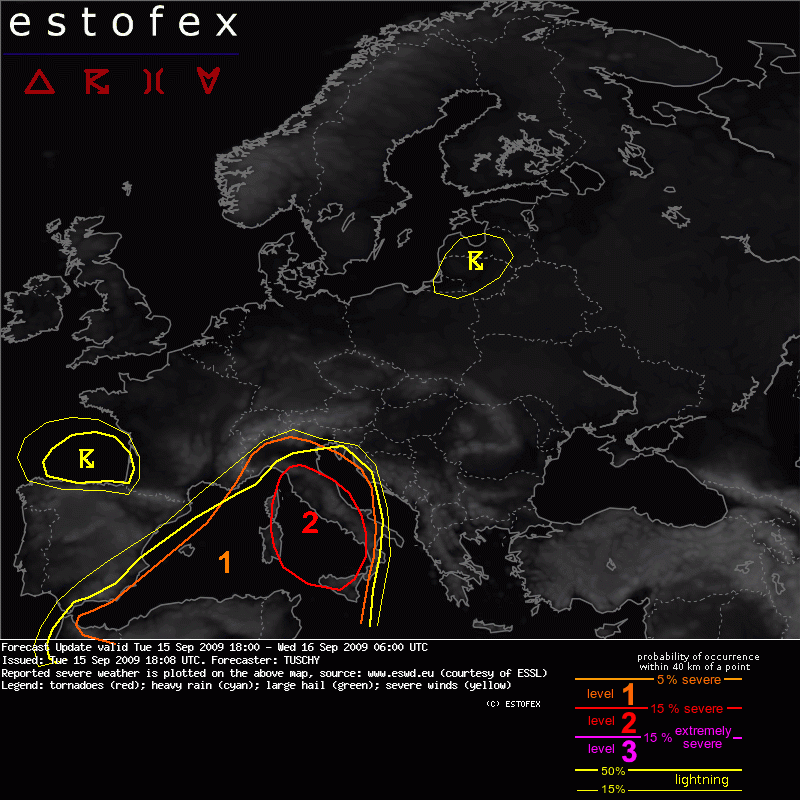
 ESTOFEX WARNING 2 for Sardinia, Corsica and the Tyrrhenian Sea:
Storm Forecast:
ESTOFEX WARNING 2 for Sardinia, Corsica and the Tyrrhenian Sea:
Storm Forecast:
Valid: Tue 15 Sep 2009 06:00 to Wed 16 Sep 2009 06:00 UTC
A
Level 2 was issued for
Sardinia,
Corsica and the N-
Tyrrhenian Sea mainly for large hail,
severe wind gusts,
tornadoes and
excessive rainfall.
A
Level 1 was issued for the
western Mediterranean mainly for
excessive rain and
tornadoes.
At the surface, the exact surface pressure evolution is not clear with global models like
GFS,
ECMWF,
GEM and
WRF all show a developing depression over the Balearic Islands during the morning hours, moving constantly to the northeast with gradual intensification (
WRF the
most aggressive one with a sub-1000hPa central pressure west of Corsica at the end of the forecast). The local MM5/
WAM however hint on
numerous cyclonic vortices to evolve over the western Mediterranean with a more easterly track compared to the global models.
The slowly consolidating surface depression, the passage of the mid/upper disturbances from the SW and a moist air mass throughout the troposphere display a good environment for repeated, slow moving thunderstorms with a
flash flood risk especially
over the Balearic Islands.
Another risk arises with increasing 0-3km
CAPE release,
LCL height of at or below 500m and outflow boundaries from
decaying storms, which point to a
tornado/waterspout risk.
Latest AVHRR
SST has a tongue of
very warm waters east of Sardinia and Tunisia with
SST values of
25-28°C and even higher values south of Sicily. This is in line with an impressive positive
SST anomaly west of Italy of 3°C to more than 4°C (OISST).
The main focus for initiation will be the approach of a strong mid-/upper impulse from N-Algeria, resulting in increasingly diffluent conditions over the area of interest.
GFS also forecast a potential coupled jet configuration between a polar front
jet streak over S-France and a subtropical streak over extreme N-Africa. The environment for intense lift will overspread the region from the SW during the night hours.
The airmass remains capped during the day with WAA (850hPa 20°C-isotherm approaches Sardinia during the night) but rapidly steepening lapse rates and high BL moisture content above the
very warm waters cause a rapid
CAPE build-up. Even the more reluctant
ECMWF develops a tongue of more than 3000 J/kg MLCAPE with ICAPE approaching 4000 kJ/m^2 west of Sicily and east of Sardinia during the morning hours.
The air mass remains capped offshore well into the night, so
explosive thunderstorm development is forecast first over Sardinia and Corsica, moving rapidly towards the NE. Later on, thunderstorm initiation becomes also increasingly likely over the
Tyrrhenian Sea as cap erodes. Any developing thunderstorm gains organization rapidly with a
very large hail,
severe wind gusts and
tornado threat first over
Sardinia and
Corsica, spreading rapidly northeastward and affecting the west-
central coast of Italy during the morning hours.
A constantly strengthening
LLJ helps to advect the very moist air to the north, feeding developing thunderstorms with moisture, so excessive rainfall is a major threat, especially if backbuilding into the moisture source region occurs. Just at the end of the forecast,
WRF has an eastward moving convergence zone over the
Tyrrhenian Sea with an extremely unstable prefrontal air mass, so the risk constantly shifts southeastwards and will continue after 06Z (next forecast period).
The level-2 was issued for the organized thunderstorm risk but also for excessive rain over Sardinia and Corsica. Later model and remote sensing data will be studied for a southward expansion of the level 2 area as models differ significantly when initiation ought to take place west and over of
Sicily.


 Permessi di Scrittura


 Rispondi Citando

Segnalibri