

A scanso di equivoci:
Numerical weather prediction models become progressively less reliable beyond 120-144 hours (5-6 days) due to the chaotic nature of the atmosphere. To improve the quality of long-term forecasts (beyond 144 hours), statistical methods, climatological analyses, and probabilistic techniques are integrated, which are not always used for shorter-term forecasts.
Here’s a summary of why and how these approaches are applied:
1. The Chaotic Nature of the Atmosphere
The atmosphere is a nonlinear and chaotic system, meaning that small inaccuracies in the initial conditions of the models can amplify over time. After about 5-6 days, the uncertainty in the forecast increases to the point where purely deterministic physical models become less useful.
2. Complementary Approaches for Long-Term Forecasting
- Statistics and Climatology:
- Historical data is used to identify recurring weather patterns during certain seasons or in specific regions. For example, phenomena like El Niño or the NAO (North Atlantic Oscillation) can influence monthly or seasonal weather trends.
- Statistical forecasts help "calibrate" long-term numerical models by comparing them to past trends.
- Ensemble Prediction System (EPS):
- Many simulations are run with slight variations in initial conditions to generate a range of possible outcomes. This allows meteorologists to assess the likelihood of certain atmospheric events rather than providing a single deterministic forecast.
- Ensembles help estimate uncertainty and determine the probability of specific weather scenarios.
- Global (Climatic) Models:
- Beyond 10 days, models like GFS (Global Forecast System) or ECMWF (European Centre for Medium-Range Weather Forecasts) are often combined with climate models that account for longer-term influences, such as oceanic oscillations or large-scale atmospheric patterns.
- Probability Equations:
- Probabilistic approaches become essential. Forecasts often provide probabilistic outputs, such as: “There is a 60% chance of above-average temperatures between days 10 and 15.”
3. Differences Between Short-Term and Long-Term Forecasts
- Short-Term (0-72 hours):
- Primarily relies on physical models using dynamic equations (e.g., Navier-Stokes) that accurately simulate atmospheric phenomena like precipitation, winds, etc.
- Models incorporate high-resolution data such as radar and satellite inputs.
- Medium-Term (72-144 hours):
- Models start relying more on broader synoptic patterns, such as the movement of high and low-pressure systems, and probabilistic techniques.
- Long-Term (>144 hours):
- Forecasts become more "guided" by climatic trends, statistical patterns, and probabilistic outputs. The accuracy of specific predictions (e.g., rainfall in a city) decreases, while the focus shifts to general trends, such as temperature or precipitation patterns over larger areas.
Conclusion
Beyond 120-144 hours, weather forecasts rely on a combination of tools: physical models, historical climatological data, and probabilistic techniques. This blended approach is necessary to manage increasing uncertainty and provide useful forecasts, even if they are less detailed compared to short-term predictions.
Nelle ensemble di Gfs comincia a notarsi linsorgenza di un pattern a due onde in troposfera sul finire della seconda decade, ottimi movimenti confermati nel long 👍

Io cio che noto è anche il grande assente: l'Orso. Non c'è per nulla un serbatoio freddo/gelido ad E che andrebbe perfettamente a contrasto con l'antagonista ad W. Non ce n'è assoluta parvenza e questo dettaglio fa tantissimo la differenza nel comparto emisferico.
purtroppo le masse artiche sono tutte sbilanciate nel comparto asiatico, e di che conseguenza non c'è spazio per la formazione di un'altra pressione termica, la vedo male, ma spero di sbagliarmiOriginariamente Scritto da tornado_valley

"E che prosegua così, muoiano le retrogressioni da Est: avanzi l'Atlantico"
Heinrich (16 ottobre 2023)
Se ricordi nel 20 21 c'era un gran gelo a est, ci furono pure dei record. Nonostante ciò qua arrivarono le solite strisciate inutili. L'unica cosa chiara e ineccepibile è il trend da dopo il 2019, c'è stato ogni tipo di episodio invernale in giro per l'Europa tranne che in Italia, specialmente al centro sud.
Schivati in tutti i modi, sempre.
Senza dubbio siamo i più penalizzati.
Non credo sia come tu dici...
Le masse artiche sono e saranno sbilanciate sul continente Americano che in situazioni di AO/EA++++++ e disturbi ad una sola onda planetaria fin sulla stratosfera sono sempre le favorite....
altrove di freddo ce n'è ben poco o nulla a parte qualche refolo su alcune zone dell'Europa orientale

Ma nell ultimo periodo non mi pare che ci troviamo in AO/EA++++
La differenza tra genialità e stupidità è che la genialità ha dei limiti.
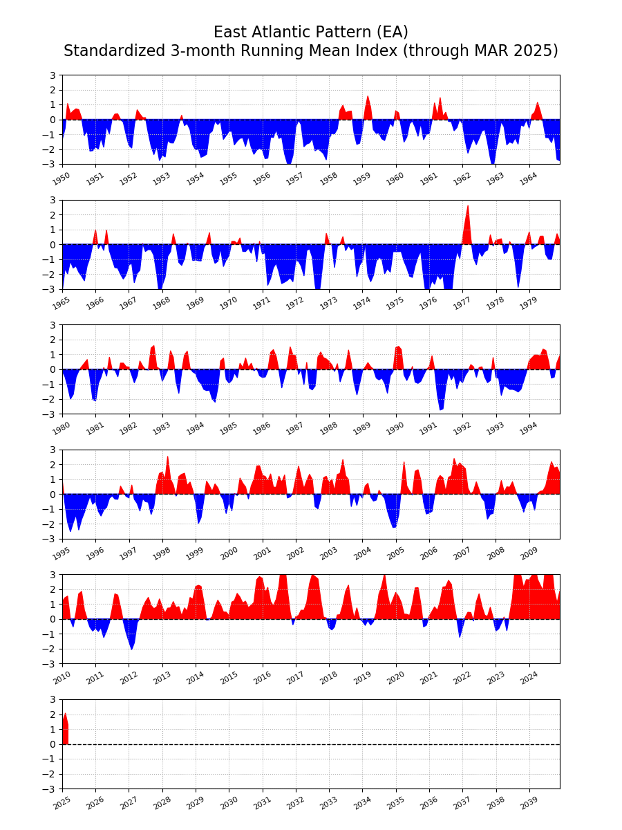
L'EA è stato neutro/debolmente negativo in alcuni momenti nel mese di dicembre, e comunque sto parlando delle configurazioni di qui a venire
Run di ECMWF abbastanza isolato
graphe0_00_0_0_13.81386_42.10158_.gif

Bene o male il 18z di gfs è sulla falsariga del precedente
Inviato dal mio iPhone utilizzando Tapatalk
 Permessi di Scrittura


 Rispondi Citando


Segnalibri