

Le reading sono impressionanti, SOPRATTUTTO nel quadro ENS ed in chiave emisferica: nell'ordine un blocco anticiclonico alto spostato un pò più verso sudest ovvero centrato fra islanda e groenlandia mentre ieri era più spostato sulla groenlandia, il chè favorirebbe un ingresso franco in area mediterranea del freddo vero, uno split del vpt GIà BEN VISIBILE A SOLE 144 H e dico 144 ORE, le ens che vedono un coriaceo e reiterato blocco in atlantico: sinceramente carte del genere previste per fine novembre ne ho viste ben poche ed ormai reading sta martellando forte verso tali scenari con aggiustamenti sempre più a vantaggio anche del nostro "misero" quadratino mediterraneo.......come se la natura volesse riequilibrare le sorti di questo piovosissimo ma finora mite novembre, in 7/8 giorni (latu freddo).....il centrosud fuori dai giochi??.....non mi parrebbe proprio , ma manco per niente ed in ogni caso dinamiche così delicate non si inquadrano certo a 200 e passa ore...

Split del VPS in bassa stratosfera. Ad ottobre solo un disassamento con frattura del vortice polare troposferico sempre il giorno 24... lo farà anche a dicembre

Andrea
Che ne dite delle proiezioni trimestrali NASA, passate da così...
... a così?

Sarà contento Fenrir di quell'hp sulla capa
Azz le proiezioni si fanno interessanti, e gia' fra 10 giorni potrebbe esserci il gelo su mezza Europa e forse anche da noi ( probabilità ancora bassa però)
You have to be trusted by the people that you lie to. Pink fLOYD
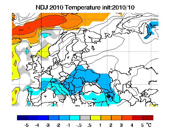
Ne abbiamo gia' discusso un paio di giorni fa. Personalmente ritengo senza senso la parte relativa alle T. Per la pressione non mi esprimo, perche' "puo' essere" (che ci sara' un dominio anticiclonico da quelle parti e' appurato) ma vorrei avere un po' di tempo per guardarmi un paio di cose. Quello che mostrano, a livello scandinavo quantomeno, e' una replica dell'inverno scorso con anomalie leggermente spostate verso est.
"You are not entitled to your opinion. You are entitled to your informed opinion. No one is entitled to be ignorant." (Harlan Ellison)
Solo io vedo le prime 2 "NDJ" e le seconde 2 "DJF"?
Se è colpa della cache non rinfrescata faccio un po' fatica a confrontare 2 periodi diversi. E se non è colpa della cache non rinfrescata invece faccio la stessa identica fatica.
Neutrofilo, normofilo, fatalistofilo: il politically correct della meteo
27/11: fuori a calci i pregiudicati. Liberazione finalmente.
Joe Bastardi riconferma in maniera egregia il prossimo inverno freddo sull'italia da nord a sud...
HELLO, EUROPE... NO CHANGE IN WINTER IDEAS ON THE THREAT OF BRUTAL COLD ALPS INTO SOUTHERN RUSSIA.
By the way, you can follow me on Twitter (I am @BigJoeBastardi). I occasionally tweet there on Europe when I don't have time for monster posts. In fact, I tweeted today.
I see nothing to back away on the idea that the core of the worst of the winter is in southern Europe into southern Russia this year. Most of the "continent" is cold and it's Ireland, northern and central Great Britain and Scandinavia that has the shot at warmer than normal. It will be a tussle in Brussels, but once south to Vienna and Berne, it's the cold that will turn people into non-believers (if they have not had enough already) that may be warm, warm, warm is not the way to go. I also think the winter is cold from Italy to Turkey. The threat of cold is no bull in Istanbul.
Having my way with words here.
In fact, I am so impressed that I think my relatives all the way to Bari, Italy, are going to see it snow this year.
For my amigos in Madrid... look out, a cold Spanish winter is on the way. In Greece and Cyprus, colder than normal. In fact, from about the 50th latitude south, this looks nasty, but centered between 40 and 45.
If you like winter cold... you'll love what's coming.
Ciao for now.
na traduzioncina please....
Originariamente Scritto da nessuno


In fact, I am so impressed that I think my relatives all the way to Bari, Italy, are going to see it snow this year.
Sito Meteo https://meteoinpuglia.it
Stazione Meteo http://meteoinpuglia.altervista.org/putignano.htm
 Permessi di Scrittura


 Rispondi Citando


Segnalibri