

Gli spaghi russi in crollo


beh oddio Alessà, proprio crollo no \as\ diciamo che ritornano gradualmente in media o leggermente sotto, il che è già un mezzo miracoloOriginariamente Scritto da Alessandro669


Si vis pacem, para bellum.
ma si, qualcosa può scappare, è un po' fisiologico nel prossimo periodo. Tuttavia, oricellisticamente parlando, ma riferendomi ad un orticello piuttosto vasto, Centro-sud in genere, sono un po' scettico su un cambiamento importante e soprattutto duraturo, poichè non vedo buona la disposizione del getto in atlantico. Nella sostanza credo che avvenga il cambio configurativo con aria artica sorpattutto, ma anche continentale, tra fine mese e marzo in maggiorre e frequente proponimento sullo scenario europeo. Tuttavia ho il timore, data una chiara pendenza a Ovest del getto subpolare, visibile in questi giorni e con incidenza tale da far presupporre insistenza, che il corridoio freddo possa preferire i meridiani centro-occidentali europei. Preferire significa maggiore frequenza verso questi settori e anche maggiore insistenza; non preferire i meridiani centro-orientali del continente ( che significherebbe freddo serio sull'Italia ) per buona parte dell'Italia, ripeto soprattutto centrosud, significa non assenza assoluta di cavi freddi ( almeno spero ) ma, nei casi in cui i cavi freddi decideranno di interessarci, questi potrebbero essere più fugaci, meno incisivi e soprattutto più rari. Insomma più mordi e fuggi per il Centorsud. Credo, invece, che il Nord possa avere più numerose e incisive occasioni di situazioni invernali e nevose con freddo succifiente per le pianure, ma il grosso potrebbe andare in Francia e anche Spagna. Ciò non toglie che possiamo avere una Lp fredda meridiana al Sud di 48/72 ore con mezzo metro in collina in Appennino. E' l'aspettativa maggiore in quel che resta di questa stagione. Quella peggiore è che le sacche vadano addirittura troppo a Ovest, quasi in Atlantico, con HP frequente su Centrosud Europa, evoluzione da mettere nel conto anche questa. Comunque seguiamo passo passo e vediamo che ne esce fuori in quel che resta di questo inverno o semestre freddo.
Dio c'è ...
Concrdo pienamente con Fabio, tranne che sul fatto che potrà trattarsi di tipiche dinamiche interstagionali: io credo che la terza decade passerà con dinamiche, finalmente, prettamente INVERNALI.
Si deve parlare di dinamiche interstagionali,dato il periodo nel quale sembra debbano intervenire,però ciò non toglie che esse potrebbero avere durata ed intensità tipiche degli eventi invernali.
Sono d'accordo.

Imho, buoni segnali da Reading 12z

"We are all star people, from the dust we came and to the dust we shall return. So let's celebrate Love. Ciao Mamma.

Il ruolo del AAM (Atmospheric Angular Momentum) e il Mountain Torque:
"Atmospheric angular momentum (AAM) provides a convenient framework to study the role of mountains, surface wind stresses and various transport mechanisms in variability ranging from intraseasonal to interdecadal and beyond. Quantitative studies are feasible with current global assimilated datasets which show a good budget balance for global integrals, intraseasonal variations and during northern winter/spring. The budgets get much worse when gravity wave drag is included, if zonal integrals are considered or during summer/fall seasons. AAM is useful as an index of the large scale zonal flow since it is highly correlated with independent length-of-day measurements and with phenomena such as the QBO, ENSO, the MJO and possibly global warming".
e poi:
"A composite study of the MJO AAM signal was performed using 30-70 day filtered data and global AAM tendency as a linear regression "predictor". Large-scale eddies forced by tropical convection were found to play a dominant role in forcing the AAM response during northern winter (November-March). As these eddies move eastward within the asymmetric basic state, they produce a poleward movement of momentum transports. When this upper tropospheric momentum source reaches the subtropics, it induces a vertically deep mass circulation and a subtropical friction torque anomaly, which causes AAM to change. For the mountain torque, a combination of equatorial Kelvin waves, forced by convection over Indonesia and then impinging on the Andes and mass exchanges along the east slopes of the Himalayas and Rockies were found. The former is more directly linked with the MJO while the latter is a residual of large amplitude, ubiquitous torques induced by mid-latitude synoptic wavetrains. In fact, a case study of an individual MJO, where the mountain torque was 3x larger than the frictional torque, prompted a linear model investigation of the torques and their role in forcing intraseasonal AAM anomalie".
"A simple Markov model of the three-component system comprised of total AAM, friction and mountain torque was developed. Statistical analysis of the observed data suggested AAM anomalies are damped on a 30 day time scale by the friction torque and forced stochastically by a "white" mountain torque and a "red" friction torque. The resulting Markov model has variances and lagged covariances that compare favorably to the observations, although systematic differences representing approximately 20-30% of the variance also emerge (see Fig. 4.9). The most prominent differences are the greater coherence between the mountain and friction torque for 10-90 day periods in the observations (see Fig. 4.9e) and the excessive AAM variance at ~2*pi*30 days (the AAM decay time scale) in the modeled spectrum (not shown)".
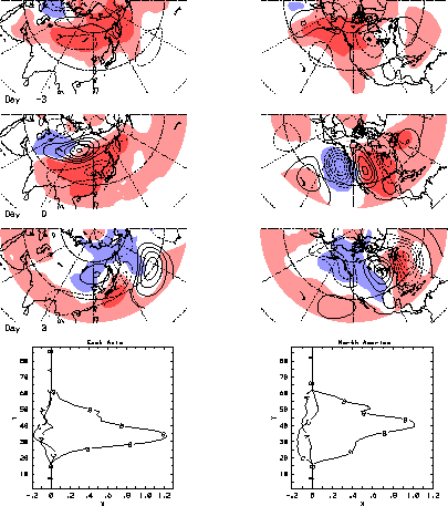
Fig. 4.9 Coherence squared (left column) and phase (right column) between the variables labeled at the top of each panel. Three curves are shown in each panel: the thick solid lines are for the observations, the smooth curves are the theoretical cross spectra and the dashed lines are based on output from a red noise model. The coherence squared and phase (in radians) are plotted as a function of Fourier frequency (cycles/366 days) with selected labels along the abscissa showing the corresponding period in days. A positive phase means the first variable labeled above each panel lags the second variable.The synoptic features associated with global mountain and frictional torques were also studied. The primary synoptic structure producing the mountain torque during northern winter is seen in Fig. 4.10. Growth of quasi-geostrophic disturbances upstream of the mountains is followed by downstream dispersion of energy across the mountains. At the surface, mass anomalies propagate southward, likely reflecting topographic Rossby wave activity forced by low level flow impinging on the mountain slopes. Zonal mean momentum anomalies produced by the torque are transported out of the latitude band of the mountain. This is accomplished partially by the quasi-geostrophic wave activity. The momentum is dissipated in adjacent latitude bands by the friction torque which responds to the upper level momentum source produced by the transports. The mass anomalies are consistent with quasi-geostrophic balance of the surface flow. The decay time scale of the global mountain torque is ~1.5 days, i.e., it is nearly white for daily data.
Fig. 4.10 The 250 mb streamfunction (contours) and sea level pressure (shading) anomalies that accompany a mountain torque over Asia (left column) and North America (right column) at days -3, 0, +3. The fourth panel in each column shows the mountain torque (Hadleys) as a function of latitude for each day. The curves labeled A, B and C correspond to days -3, 0 and 3 respectively.
gltaum.90day.gif

Matteo
Mat, non ci ho capito granchè!
Sostanzialmente l'attrito con le Rocky Mountanins inizierà ad ondulare il getto?

"We are all star people, from the dust we came and to the dust we shall return. So let's celebrate Love. Ciao Mamma.
Behh, diciamo che dal 20 febbraio, periodo individuato da tempo come possibile partenza di qualche sblocco, l'azione dovrebbe farsi più meridiana. Ma azione meridiana a scala euro-atlantica significa cavi depressionari e rimonte anticicloniche. Questo accadrà. Ora bisogna vedere dove potranno prevalere i cavi e dove i promontori di alta pressione. Ripeto, il getto atlantico non mi piace molto, intendo per cavi diretti sull'Italia o meridiani centro-orientali. La prevalenza di essi potrebbero essere verso i meridiani occidentali europei o i meridianai est atlantici, quindi ancora più in là, a Ovest. Avrei preferito vedere manovre indicanti un getto almeno verso la Sardegna, ma non ci sono indicazioni in tal senso; il getto è tendente più a Ovest, forse parecchio più a Ovest. Tutto sommato per noi sarabbe meglio questa seconda ipotesi. Cavi atlantici in oceano e rimonte anticicloniche su Europa. Rischiamo di prenderci fasi di stabilità e calura ma con l'alta pressione più presente possiamo tentare di avere anche qualche suo slancio più a nord e approfittare di qualche incursione fredda artica o continentale, sulla stregua di quanto mostra la coda di ECMWF stamani. Il rischio di nulla e, anzi, di HP sarebbe sempre presente, ma almeno ci giocheremmo qualche possiblità fredda. Fasi invernali dure da guadagnare o 1- per affondi atlantici più a Ovest, in Oceano, e rimonta di HP prevalente su Centrosud Europa e anche Italia e con deviazione, da parte dell'hp, delle ritornanti fredde artiche o dalla Russia più a est, o 2- per affondi atlantici verso l'Iberia e clima scialbo, umido, insignificante. Questi i rischi maggiori. Preferisco la prima ipotesi, come già detto, con HP e stabilità e sperare che le ritornanti da est riescano a penetrare fino a noi approfittando di temporanei cedimenti dell'HP.
Ultima modifica di granneve; 09/02/2014 alle 10:26
Dio c'è ...
 Permessi di Scrittura


 Rispondi Citando


Segnalibri